Is this ground a risk?
I am currently sitting in a small team overlooking the demolition and then reconstruction of a car park in Woking.
The project manager has tasked me with setting the piling Matt levels to allow the piling contractor a flat even surface. We have decided on two piling Matt levels (ramp and car park) across the site with a battered edge between them to allow for the different ground slabs. The street level is approximately 28.5 to give an idea of how this will look on the ground.
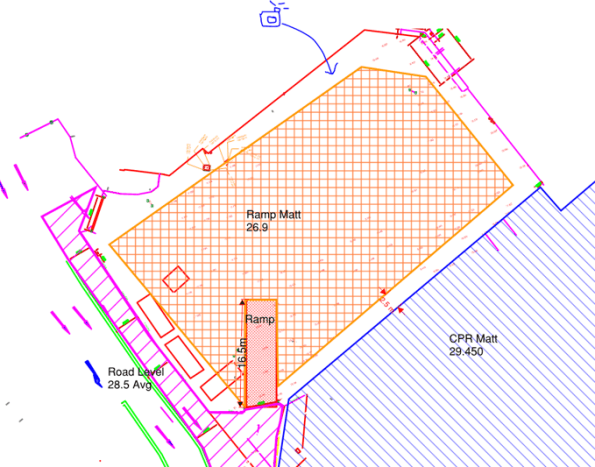
The ramp into the CPR cannot be seen on this drawing but does exist.
My main concern is with the level of the “Ramp Matt” which is adjacent to a Primark and Debenhams to the north and east. Looking at this problem it seems that we would be undermining the foundations of the existing buildings to excavate down to 26.9. Nobody seems to be able to tell me what foundations sit underneath Debenhams or provide any GI data beyond “it’s a clayey sand”. So it seems like an obvious answer, you need a retaining structure between Debenhams and the proposed piling Matt, but the plot thickens…
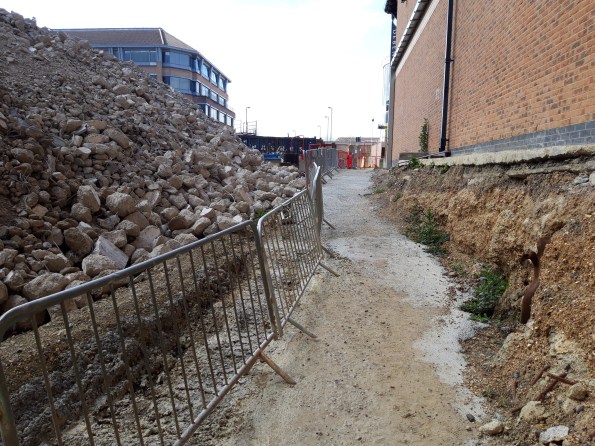
The ground has already been part excavated to allow access for workers and is standing freely. There is no evidence of the foundations under Debenhams and the ground seems to be holding. Supposedly this has been the case for the last 18 months. I asked who led with the initial excavation and it seems it was “just done”.
That photo is taken at the proposed level of the piling Matt but the ground rises into the far ground up to street level, the proposed Matt will remove that rise so the whole ground sits at the level the photo is taken at. It seems to me that the attitude is simply “it’s ok now so it’ll be ok to take the rest out” without anyone raising any alarm bells. Am I crazy or is this in need of an actual substantial design?

Hmm, There be dragons…. looks like the existing excavation has undermined the brick curtain wall footing already but probably not got near the structural footings of the building itself. I’d be a bit more worried about the two major rainwater downpipes tucked around the corner and the fibre optic cable BT exchange box. There will be a site survey somewhere with more information on. You wouldn’t be excavating without a need and certainly won’t be piling without a full GI so there’s some data you’ve not got somewhere. There might also be a party wall agreement somewhere that is being flaunted?
Richard, I can’t add photos to this reply, which would better show it but those down pipes and the BT box will not be included in the extent of the excavation.
I will continue to look for a GI/survey, but as this was never an original part of the works and is a very large client instruction there is a lot of missing desk work. The piling is still out to tender and the road and service work is still in its design stage. The overall site GI states a “very silty sand” overlaying a London clay but no exploration was done on the car park.
James A supplied me with the ground profile for the site from about 28 AoD down to 23Aod is a weathered clay. I think we can see this in the photo; then its an interbedded sand/clay sequence common for the Lambeth Beds
For a sizable structure I’d think that the o/c clay layers imply this structure as piled
In this case you should be able to see the edge ground beam and guess at the pile cap spacing along the wall run – say 6m c/c?
I’d make sure using a trial pit or two to confirm before you lower the rest of the excavation
I’d like to think that they did this before exposure of what I can see
You’re certainly right to ask
As there is due to be a retaining structure there eventually I have suggested that it is constructed early to support the temporary state. I will endeavour to find the party wall agreement as I am sure there is the information I need in there.