Quantity Surveying Using Drones
I’m currently in my fourth month of a site attachment with Seymour Whyte Construction (Melbourne, Australia) and involved in the upgrade of a 5km road. Undoubtedly, one of the most utilised (and cost-effective) tools we have at our disposal is the drone. No one reading this will be unfamiliar with the use of drones for aerial imagery capture. However, I wanted to share my experiences of how we have been using this data for engineering specific purposes.
Our software of choice is Propellor (propelleraero.com), used for drone-based data collection, processing, and analysis of earthworks. As frequently as required (usually once a month), our survey manager sends his drone fleet on a pre-determined flight path, covering the entire 5km site within an hour. The data is then uploaded to a cloud service and processed using photogrammetry to create a realistic, fully interactive 3D site model.
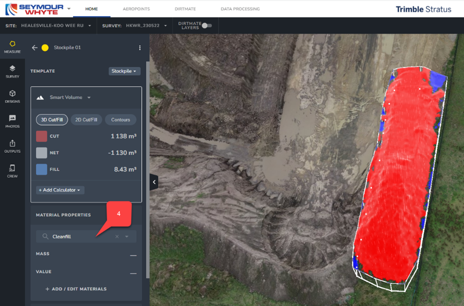
We then use this model for a variety of measurement and management purposes. One of the most useful (and time efficient) processes is the production of quantity take off spreadsheets for end of month financial reviews. The software is able to identify total quantities placed (broken down into specific material types) during the given financial month. We then subtract these quantities from final design quantities to determine what is remaining. Each material type and corresponding construction methodology has a cost rate associated with it (per m3). Once the quantity remaining value is updated, our financial forecast to complete automatically updates.
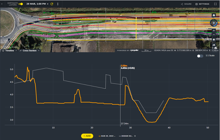
Coupled with machine tracking systems (Spotlight on DirtMate: How Does it Work? – Propeller (propelleraero.com) we can also use this data for daily progress tracking, cost tracking and material stockpile measurements. With the ability to cut 3D cross sections across the live site model, Propeller can also be used to overlay design drawings on the section, allowing for quick visualisation of material level against FSL.
I wonder if anyone has had other experiences of quantity take off for the purposes of EOM financial reviews? Should our surveyors, and by extension PET students, be learning about some of this technology during Phase 1?
Given that drones are now commonplace in the military context, should we be investigating the potential uses of ME specific drone data processing software? An immediate thought is the benefit of 3-dimensional drone measuring for the purpose of crossing point reconnaissance or for the automation of cut/fill quantities as a planning tool for military earthworks.


Jamie, thanks for the post. It is good to know what civilian industry is doing. I don’t believe we have this capability yet in the RE. I will pass the post onto the relevant team in tech training branch.
An interesting concept but I wonder about some of the practicalities – not a grilling and not by default sceptical of technology I promise!
1. How is the drone image capture calibrated? I.e. how does the drone know what it’s looking at is indeed, what it’s looking at? For instance does the QS have to sit down and program sample images or verify? I know we briefly tried using a rock identifier mobile app for similar and I’m sure John M would shudder at the thought of such a process ruling the analysis side….
2. Is there some sort of assurance check? Does QS need to verify perhaps 10% of the measurement in much the same way we do hand calcs of design software to prevent cumulative errors taking hold.
3. Does weather effect it? If a drainage pathway, for example, becomes waterlogged how does the drone know what the true profile and therefore the volume is if it’s full of water?
I know 22 Engr Regt Recce troop did some experimentation with drone assisted gap crossing back in 2020. It was mainly photographs imposed on the LIDAR scan but the data could easily be extracted from the model (wet gap width, AR distance, near and far bank heights etc).
How long does it take for the data to be processed into the 3D model? I know Geo have done LIDAR surveys in the past and can collect the data in a quick timeframe, but it was the processing time of it and inability to interact with the archaic ComBAT system that made it pretty useless to for BG/Bde planning cycle.