Water, water, everywhere
It’s been a hectic couple of weeks, with several issues occurring as we excavate further but I try to remind myself that its all great experience!!
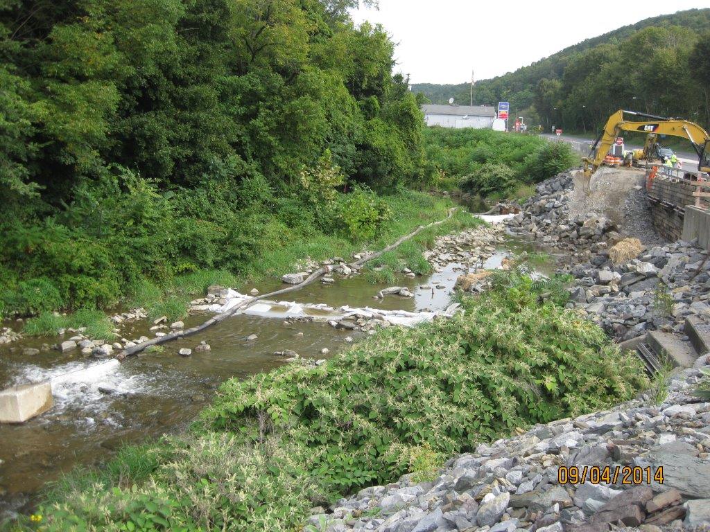
Looking north; river flowing towards the viewer. Dewatering partly in place – dammed upstream and down, with water being pumped around site.
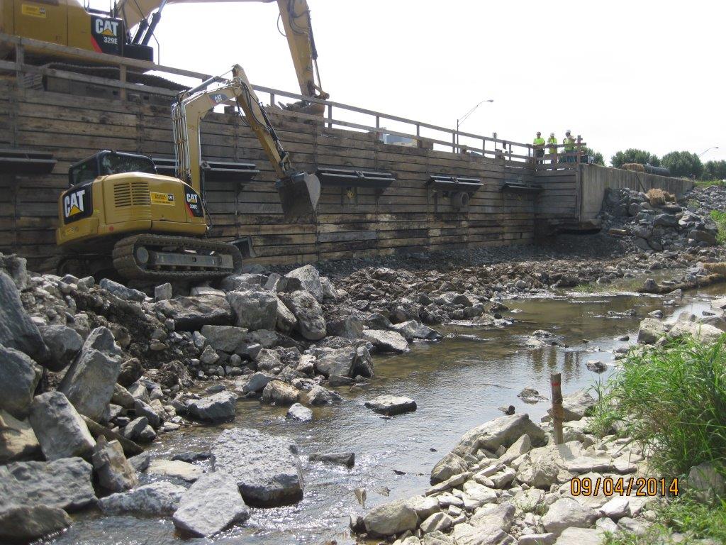
Looking at site from across the river, supposedly mostly dewatered. Note stake in foreground shows limit of excavation for the dug-toe.
As usual, pretty much everything problematic has been a result of water! Upon reaching the limit of excavation at the base of the shoring (13ft) and reviewing submittals for the structural fill I had some major concerns:
- The excavation was starting to get wet underfoot, plus I could see (in concert with some local knowledge) that the visible river at 1-2ft deep was actually running several feet deeper and was flowing under our site following its original path under the retaining wall and the highway. This tied into the issue that was raised by the tie-back drillers that they were hitting water at 15-20ft. Annoyingly the original borehole logs down to 28ft do not show any indication of water on them – not helpful!
- The dewatering was having minimal effect; there was more pumping to occur within the two dammed walls (pic top left) but it was evident that it would be nigh on impossible to dry the area in order to excavate the ‘dug-toe’, and then lay the proposed structural fill (lean clay) and compact it to 98% of lab dry density. (Readers may see the system as somewhat Heath-Robinson but we are ham-strung by the Env Agency design manual, and the inability to have any plant in the water – it was too late in the day to design a causeway and build a by-channel, plus see notes at para 1)
- As mentioned above, the submittal for the structural fill was a low-plasticity clay – the purpose was to produce an impervious layer across the site. However, if you have a look at Sheet C-303 below you will notice that the clay extends from the base of the toe all the way up to the edge of the shoring; more concerning is that the concrete wall sits on it. How on earth is a wall going to be structurally stable sitting on clay which will continually be dried out and saturated (note the mark of ‘normal water level’ – 5ft above where it is at present)???
- The damaged wall in 3 x 30ft sections had fallen at different angles. I managed to work out what was where by measuring what was poking out, and what was embedded and at what angle. The concern was the amount still embedded below the limit of excavation, and that a huge amount of sediment was entering the river downstream of the site whenever the wall was being broken up (additional evidence that the river is flowing under the site).
- A void was visible on the south side of the site underneath the existing wall – clearly caused by erosion once the wall had fallen. Rebar was also exposed and the water joins were ripped (see pic).
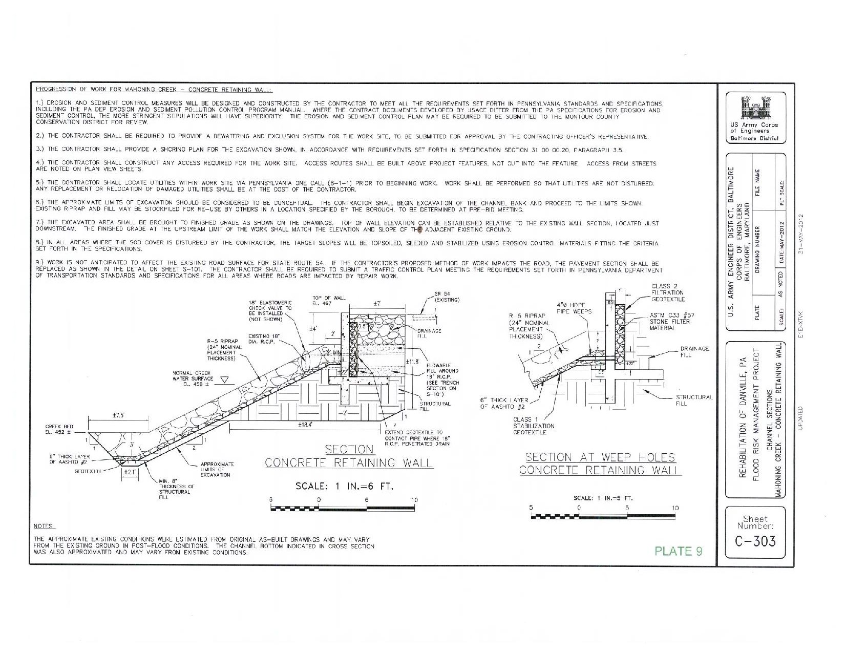
Original design
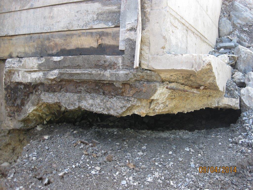
Void underneath existing wall to the south of the site
Additional limitations. Predominantly timelines…
- The Environmental Dept informed the contractor that wild trout egg stocking was to take place on 1 Oct thus the river will be in lockdown for any in-water works from 1 Oct – 23 Dec..that leaves us 3.5 weeks! Annoying that we didn’t know this as a limitation at the start (why not? I beg the question, have we got ourselves to blame?)
- The Env Dept stipulates that the dewatering scheme chosen must have a maximum lifespan of 2 weeks otherwise a new bypass system was to be designed. The contractor, without me knowing, essentially pushed himself into a corner by installing it as soon as we had approved it assuming that the E&S approval would follow shortly behind…it didn’t, it was disapproved and needed significant redesign. This put extra pressure in making any changes; some may say that is their issue/ fault – it is but we all want to get a solution in place, if we sat back, the project would fail, no funding was in place for next year and we’d be left with an open excavation, so we were all pushed into a corner somewhat!
Several conference calls later and many hours of brain-racking through options with the USACE depts of geo-tech, civil works and structures we came up with a multi-faceted solution (see pic below). The embedded original wall would be left in-situ for fear of incurring additional sedimentation, plus enabling staying on track with timelines and the consensus that it may actually help in preventing scour. The dug-toe would be removed and a new design incorporating an ‘anchor stone’ and additional reinforcing rock armour would be used (see pic), while the structural fill specification would be hastily changed from clay to a coarse gravel; this would negate the need for major dewatering and speed up time of construction. We all now have to be on the ball with processing submittals asap to meet the 1 Oct 14 hardstop. This now leaves the painful part of change orders and/or REAs but needs-must.

Slope redesign
I am pleased to say that the H&S and QC has made a dramatic turn following the insertion of the 3rd party assessor by the contractor. It is clear that morale has dived a little amongst those on site following some serious whippings, but I have no doubt they will take it on the chin and move on. It is good news, and the assessor confirmed with me that things were far from where they should be! He’ll be on site until things reach my stipulated levels per USACE specs, and then a bit longer to ensure it is maintained. He even phoned the county sheriff direct raising his concern the morning I arrived on site that some drivers were driving past at 70mph in a work zone and 35mph limit. Cue a cop-car with speed gun on site within an hour and some great viewing of law enforcement US-style in action!
We also had a ‘congressional tasker’ (akin to the Complaints Commissioner writing directly to the CO!) …cue flapping all round. The ‘tasker’ stemmed from a Danville local writing to the Congressman on the back of a fag-packet his concerns that the project was a ‘waste of money’, because we are building the wall the same as was originally placed, and that the original wall collapsed as a result of scour to its rear. He was quite correct, but federal law (PL84) has tied our hands and dictates that disaster relief work on hydraulic related projects are done on an as-built basis. Several conference calls later, the attached letter was produced.

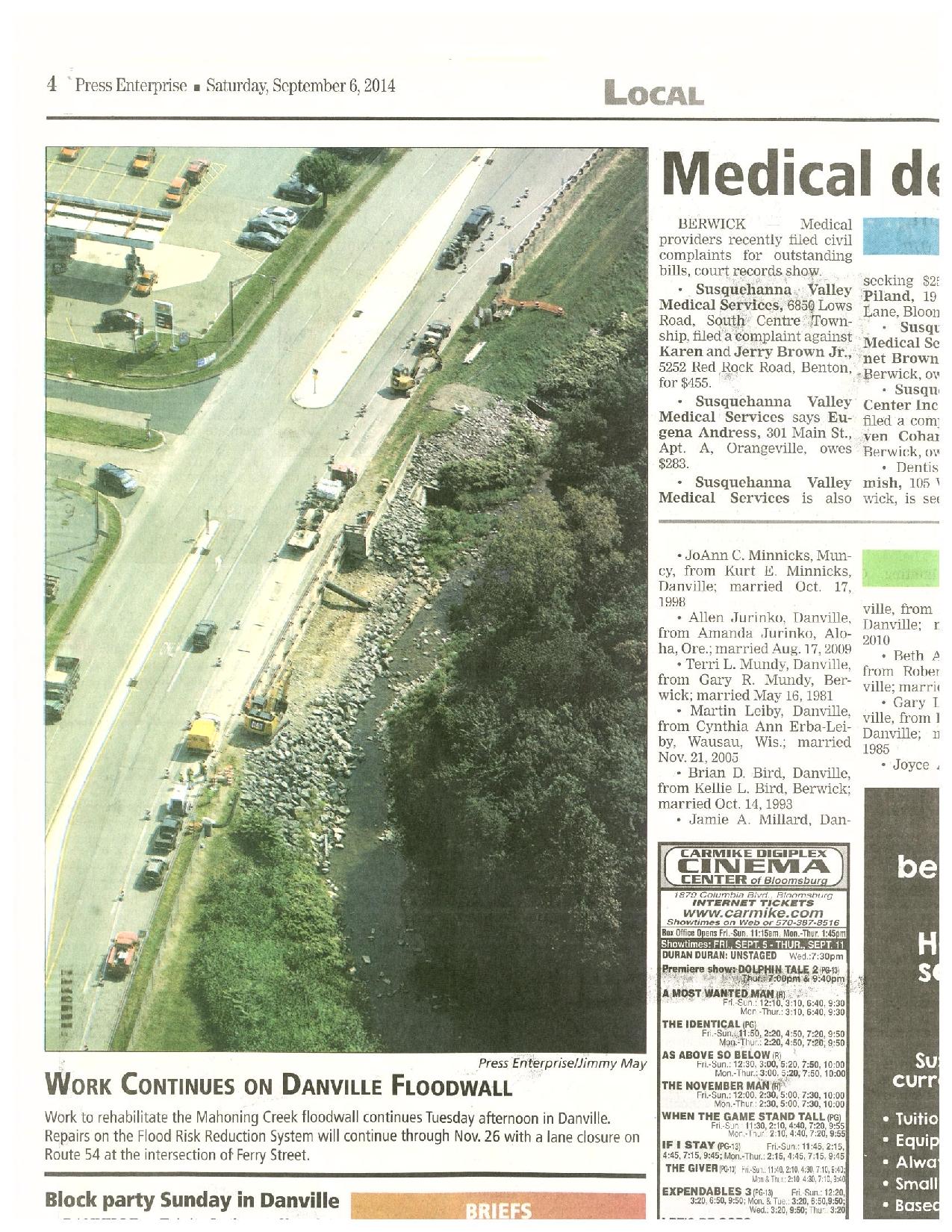
Plus, a bit of media publicity…
Also, this weekend sees the national ‘Star Spangled Banner’ celebration taking place in Baltimore’s inner harbour…100s of tall ships, Blue Angels flying displays etc – all to celebrate the 20oth year to the day from which the USA hangs its history…the first location to withstand bombardment from the Royal Navy, raising the stars and stripes for the first time, and providing the backdrop from which to write the national anthem! We will of course be attending…in a disguise of dodgy stars and stripes sunglasses and a Dunkin’ Doughnuts coffee permanently clasped in our hand; no-one will guess we’re British!? In other news, and not that we’re competing with the other HRH but maintaining the tradition of Phase 3, Emily is pregnant with our 3rd!
