Better late than never.
This blog has been sat on my laptop awaiting publication for some time and whilst now out of date I think it is still worthwhile publishing. Much of this also formed the basis for AER 3 so you can exit at this stage if you have read that document! I wrote this towards the end of my time at Graham Construction in mid November.
I have reverted to publishing this blog as my brain is aching after being set a timber and steel construction tutorial by the senior chartered structural engineer, who’s office I have been moved into and sit directly opposite. Joy.
Blog from mid-November.
The last few weeks have seen me of focussing on trying to eliminate a few outstanding development objectives that I need to have achieved by the end of phase 2. I have been concentrating less on the physical construction of structures that dominated my previous time on site and more on the commercial and managerial aspects of leading up to the construction activities.
Sub Station 18.
I have mentioned on previous blogs that I have been given an independent command of a small sub-station at the east end of the docks, a couple of miles from the current IRFT site. Whilst not the largest project in terms of real estate and value it has allowed me to take a project from proposal to the early stages of construction. I will not see it completed but have assisted in building the 2 other substations on the IRFT site and as such it will allow me to hit the DO’s I am short on.
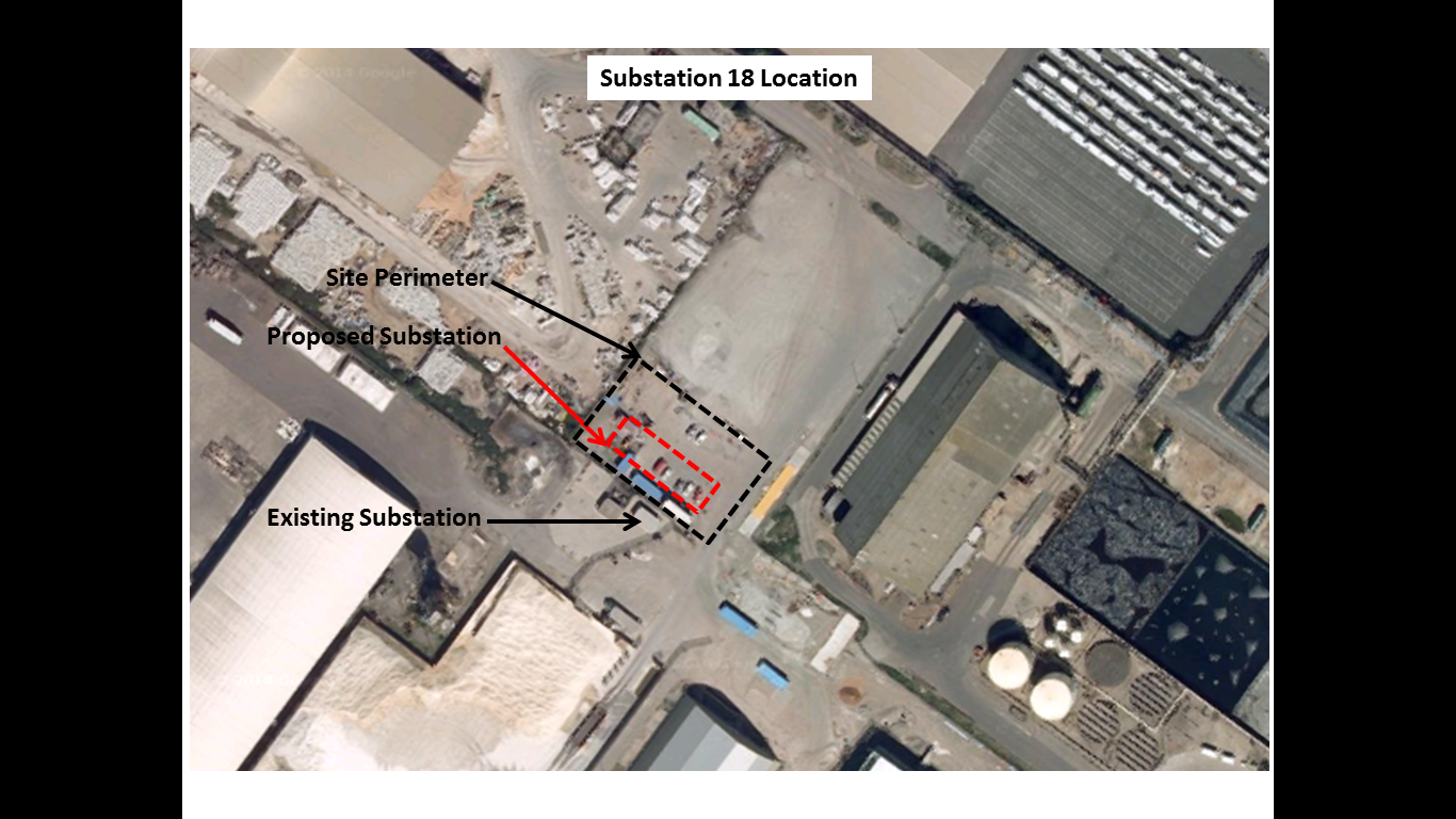
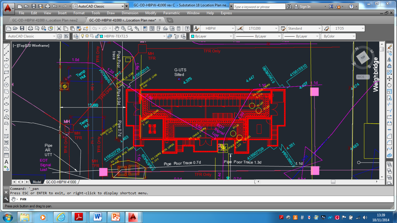
Sub 18 Location
Proposal.
The new substation is required to replace an existing substation situated north of the chosen site that was subjected to extensive flooding during last winter’s tidal surge up the Humber Estuary. The location and pre-tender service drawings have been provided by the client and the design has been produced by the consultancy for the QS’s to produce a tender price (approx. £300,000). The contract has yet to be awarded but ABP were keen to conduct a site investigation in the proposed area in the knowledge that the location is a well-used brownfield site with a legacy of industrial use. There are a number of documents out there on how to conduct a site investigation. I referred to the AGS (Association of Geotechnical and Geoenvironmental Specialists) for guidance and used their checklist for site investigations to keep me straight. http://www.ags.org.uk/aboutbusiness/bestpractice.php
It is likely that that the contract will be either a variation order to the IRFT contract or a negotiated contract due to the specialist skills accrued by Graham in construction of the previous substations to the ABP specification. This would reduce the costs of tendering and has allowed for early contractor involvement. Whilst the competitive element is reduced the relationship between ABP and Graham is sufficiently strong to allow for robust negotiations. Until the contract is formally awarded all the works I have conducted have been charged to ABP through Operational Record Sheets but if Graham win the work the cost may be negotiated into the overall tender price for the construction due to the increased rates on an ORS.
My first task was to hold a meeting with the client to firm up this detail and then walk the site with them to understand their intent as part of the pre-tender process. I then wrote a RAMS covering the set up and establishment of a new site, reviewed the substation construction RAMS from the previous builds, drafted a programme of activity for the set up and works and completed a number of permits for excavation and working around live electrical services.

Sub 18 Programme of Activity
Feasibility.
Desk study.
My pavlovian response to approaching and shaping the SI was ‘what are the risks’ both technically and from a commercial prospective, financially? The pre-tender service drawings provided by the client were clearly dated and inaccurate but gave a good enough picture of the number of services that I may encounter during any investigation works. This led to the early conclusion that the main risks would be to the cost of the project in dealing with the services and not necessarily the risks posed to the design by the soil properties. This notion was strengthened by my previous experiences during my construction activities at the IRFT having had no issues with the ground (apart from a few broken piles!). Whilst the preliminary design was completed I could directly influence the final design through the findings during my GI. The structure itself whilst over 8m in height, has only the cable pits and ground slab, approx. 2m worth of structure below the current ground level of 4.4m AOD. Despite my confidence I did know that it was important to understand the groundwater regime and so got onto the British Geological Survey’s website to locate the nearest borehole to my site. The boreholes were 1947 trail water boreholes and indicated a rest water level of approximately 3.0m AOD close to my site. This made sense given the proximity to the docks, mean tide level and previous experience. The boreholes also indicated that the surface strata comprised top soils with black mud followed by varying depths of stiff clay and pebbles. The stiff clays feature from around 3.5m AOD, approximately 1.0m below the ground surface and due to the water level would demonstrate undrained fine grained material properties. This gave me the confidence that the strength during any excavation work, unloading the soil (short term) would be sufficient. Due to my previous excavations on the main site, in similar soil conditions, and the obvious low permeability I was also confident that any water seepage could be controlled by the standard 2” submersible pumps. This information furthered my notion that the risks in the ground were unlikely to come from that material properties or the groundwater regime. It was clear to me that the risks would be in what we physically found in the ground both to the excavating team and the cost.
The next phase was for me to check the historical records and identify any existing services which was easier said than done. The historical drawings provided by the client were dated and only included recent client constructed additions to the site area and not a great deal of legacy information. However I complied what data I could find and found that the best results were obtained from my site walkabout to ID manholes, resurfaced channels, lighting , inspection chambers etc and then chatting to all the ‘old boys’ working in and around the site who provided a wealth of information having worked on the docks their whole lives. This was all compiled into a working document as the initial stage of the GI report.
Design. Phased Investigation.
Non – intrusive Investigation.
Once I had gathered all this information I contracted SUBSCAN (Sub-surface survey contractor) to complete a GPR survey of the entire area, based on my previous experiences (HV strike) and the proximity to the existing substation to be replaced. Once again the GPR survey proved its worth as a substantial number of unknown electrical and non-electrical services were identified that were not shown on any drawing or identifiable from the site walkover I confirmed the location of these services with the CAT SCAN and then did my best Art Attack effort with about 5 tins of spray to highlight every known service prior to any intrusive investigation.
Intrusive Investigation.
The next phase was to dig a number of trial holes and slit trenches to expose and confirm the services, their condition and generate a solution to dealing with them. This is where the true extent of the services was revealed and we found a whole host of legacy pipes, cables, piles, manholes, concrete chambers, railway lines etc. It took a couple of weeks to actually expose the full extent of what we found in the ground as the more we looked the more we found. Even after a thorough desk study and non-intrusive survey I still found unrecorded services but we had no H&S incidents. I also took samples for contamination analysis and sent them to ESG for a full suite of tests. At the end of the intrusive investigation it was clear that the clients proposed sub-station location would involve a substantial amount of ground works to accommodate the structure. This work included temporary diversion of 5 electrical cables, removal of a 20mx5mx 3m deep concrete chamber built inside an insitu steel pile cofferdam housing 2 x Victorian cast iron power station water cooling pipes (500&750mm), a railway line, 8 PC RC piles, 4 cast iron water pipes and 2 associated manholes and a number of drains. None of this work was expected and would be added to the tender cost.
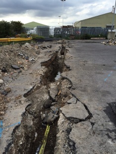
Sub 18 – Intrusive Investigation
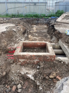
Sub 18 – Intrusive Investigation

Sub 18 – Intrusive Investigation
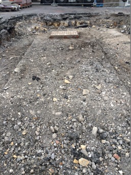
Sub 18 – Intrusive Investigation
Geological Report/Interpretation.
Due to the speed of the discoveries I kept a drip feed of information flowing to the design co-ordinator and the clients representative, holding a couple of meetings to discuss my findings and suggesting the best way to proceed. At the end of my intrusive investigation I put together a powerpoint presentation and CAD drawing to summarise the points I had written in the geotechnical report that I had been concurrently writing on the site. I found that this was the best way to portray my points clearly without having to trawl through a full geotechnical report. I recommended a shift in the substation location that would minimise the amount of work required to relocate the services thus reducing the cost and construction time. I plotted this out on the ground and walked the client through the proposal. I outlined where I thought there were still risks to the construction and design which were predominately focused on access for construction and subsequent installation of the transformers and the undermining of the various services to get all the HV lines into the substation whilst maintaining the minimum 1m cover. I also fed these point back to the design co-ordinator.
Sub 18 – Results of Non Intrusive and Intrusive Investigation

Sub 18 – My revised location republished by the designers for client approval
Detailed Design.
The detailed design was published last week and the client has now completely revised the location. The substation has been moved to the west of the current location, inside a restricted fertiliser handling facility. The driver behind this decision is the expected cost of the ground works required, even with my revised location, and the value of the site for future commercial use, when compared to the new location. In my opinion there will not be a saving in the ground works as the new location is likely to be as service ridden as the previous but I suspect the future proofing of the location and cost of land is the main factor. This is especially the case when you consider the works we have subsequently conducted to re-instate the trail holes (backfill, 150mm aggregate, roadsaw to cut straight edge, tarmac subcontractor to re-surface, etc) not to mention the asbestos I found and have subsequently had removed on the second site walkover.
So I am now repeating the process. I have edited my RAMS for site establishment, completed my site walkover, amended the desk study and re-contracted sub-scan who are in today.
So what did I learn?
Despite being slightly frustrated at having put in so much work on the initial site for it to be moved, I completely understand the long term commercial consideration on future land use and rental potential. However I am convinced that greater analysis by the client at the proposal stage would have highlighted this consideration and saved them a not insignificant amount of money on the work to date. I have yet to receive the updated costings from the QS team, but it is likely all the SI and subsequent reinstatement work will cost approximately £40,000. This is not including a figure for the SI work still to be conducted for the new location and is a significant additional cost for a £300,000 project. In the green, it’s not even a question 4 moment, as the situation hasn’t changed, in this occasion the fault lies with the BGE as there has clearly been an inadequate IPB. Sorry for the stinking chat.
When given the task, I looked for a handrail and was surprised to find no national specification and method of measurement for site and ground investigations. It would have been useful to have had a one hit document based on current ICE specifications but augmented to accommodate the philosophy of Eurocode 7. There are any number of GI handrails available written by a host of private companies, local authorities and geotechnical experts but I was surprised by the lack of a coherent national document especially to guide non geotechnical engineers through low level site investigation. Exercise Cofferdam formed the basis of my knowledge on the compilation of a geotechnical report.
This leads onto my next point as it struck me as the type of activity I may undertake when back in the green. Whilst not hard core geotechnical engineering involving interpretation of material properties and utilisation of that data for design, the nature of the investigation and commercial considerations have been an important lesson. I can envisage similar circumstances where it is unlikely that we will have a true geotechnical engineering specialist available but there is the requirement to assess the risks in the ground , both physically and commercially and communicated those accordingly to a client.
Now back to my web buckling checks…..

Just as good as it was when I read it AER3 🙂 Begs the question whether the military should have a standard method of measurement and specification for ground investigations if only to be used internally for the avoidance of doubt between psrts of the same organisation – volunteering to produce useful ME Vol material?
There is a Specification for Ground Investigation from the ICE (2012) and the document has an Annex which gives a BoQ so it serves as a method of meausrement.. It is designed for use with NEC 3. Becuse BS EN 1997 is supported by so much NCCI I’d recommend use with the old BS 5930 ( Code of practive for site invesigation and possilbe BS 10175 ( Guidance for SI on potentially contaminated land)
Richard, You raise an interesting point as Inclusion in the ME Vol would no doubt be useful but my instincts are that it wouldn’t necessarily be used that much? I suspect that any SI we as PQE’s would have to consider would need to be completed in a commercially viable format for potential use with a civilian client/contractor at a later date? I thought most SI done in the green involved a wander about site with a brew and a quick heel kick into the top soil…
John, I did fid the ICE UK specification for GI which would have been very useful but it didn’t really warrant £54 of my hard earned salary. Perhaps ill pop it on my Christmas wish list.